


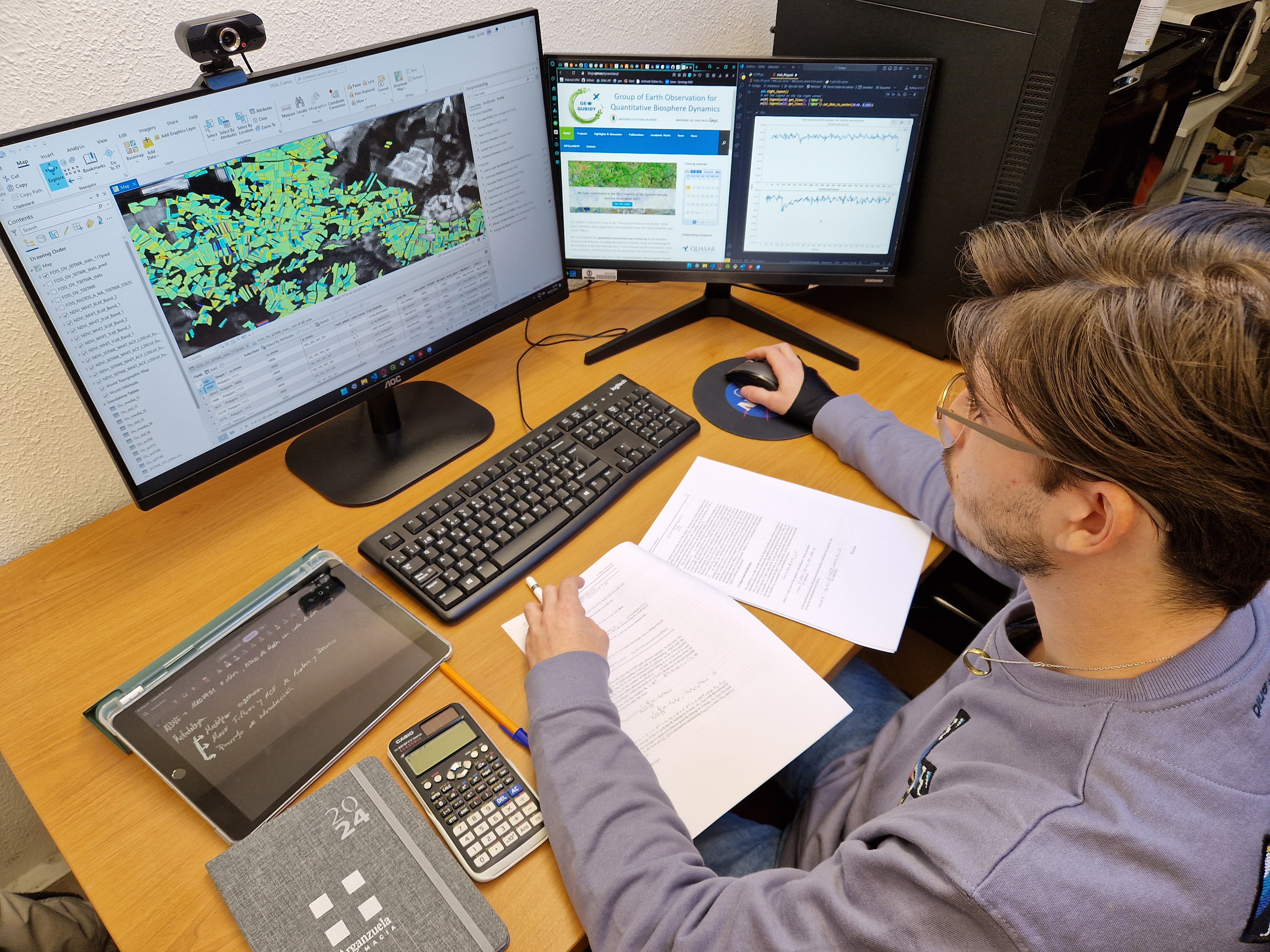
How does Dynamicland work?
The main objective of the INFOLANDYN project is to design and implement an Information System that allows the development and provision of products related to the dynamics of the Earth's surface derived from time series of remote sensing, at different scales. To achieve this goal, a process of design and development of a web-based Information System will be carried out, which includes the selection and configuration of remote sensing tools, as well as the development of algorithms for the generation of products, among other relevant elements.
Arquitecture of the Information System Dynamicland-Qubidy

The products that will be developed include phenological and dynamic indicators, as well as cartographic products. To identify the most relevant and useful indicators and products, a process of research and development will be carried out, which will allow the implementation of suitable algorithms and techniques to generate these products. In addition, the continuous review and updating of the developed products will be guaranteed, thanks to a data and product management plan that will be implemented within the framework of the project.
Products and levels
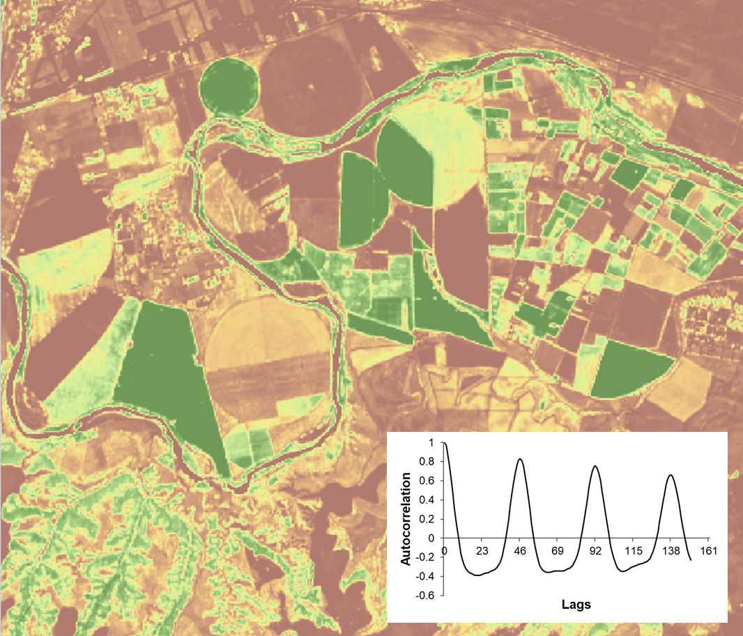
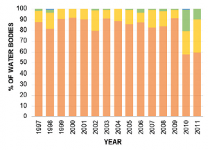
Cartographic products at two levels will be developed: (1) first level will consist of products representing the general attributes of vegetation index time series based on statistical and phenological methods, such as inflection points or autocorrelation values at specific lags, (2) in a second level the “Ready to Use” products will consist on environmental information related to the processes happening at the land surface, such as maps of the beginning of the growing cycles or the date of harvest. In addition, analyses and reports will be generated.
Satellite Data:
Level A of the INFOLANDYN project involves the collection, processing, and index calculation of raw remote sensing data, as well as the development of algorithms to transform the data into useful information. Raw satellite images will be available for download, as well as the ones with the different filters applied. In addition, the different indexes calculated for each project will also be available for download.
Statistical products:
Level B provides results from statistical procedures applied at pixel level. They come in form of a graphical product that can be altered and worked with. Each pixel holds information of different statistical parameters that could be later translated into new indexes with ecological meaning through the time series analysis, identifying patterns and changes in vegetation.
Indicators:
Indicators are measurements or variables that provide insight into complex systems or processes, and in the context of land surface dynamics, they help assess global change impacts and inform management decisions related to natural resources and agricultural lands. This project aims to develop clear and objective indicators of land surface dynamics derived from remote sensing time series, including vegetation intra-annual dynamics, inter-annual patterns, trends, structural changes, forecasting models, onset and end of growing season, and climate impact indicators.
Environmental statistics:
Environmental statistics is a subfield of statistics that involves the collection, analysis, and interpretation of environmental data to identify patterns and trends, assess data accuracy and reliability, and make predictions about future environmental conditions. It plays a crucial role in understanding complex environmental systems and informing management decisions related to natural resources and the environment.
Papers & Reports:
Papers are a key output of the land surface dynamics information system developed in this project. They include information on the methods used to develop indicators and cartographic products, results of statistical and machine learning analyses to understand the ecological meaning of indicators.
Reports provide a comprehensive summary of these papers and recommendations for management and policy decisions based on scientific evidence.
Addressing the Needs of Different Roles
This approach promotes data security while enabling users to access relevant resources. Additionally, comprehensive user support, including onboarding, training, and timely assistance, fosters effective communication, collaboration, and productivity. By addressing the distinct requirements of different roles, INFOLANDYN empowers users to make informed decisions and drive positive environmental impact.
User Segmentation
| PRODUCTS | STAKEHOLDERS |
|---|---|
| A: (Satellite Imagery) | Experts in Earth Observation Data and Products |
| B: (Statistics Products) | Experts in data analysis but not especially in the territorial field, among other experts in statistics and computer science |
| C: (Environmental information) | Statistics that work with environmental information or managers that understand the territorial scope |
| D: (Environmental statistics) | Managers using the information already synthesized |
| E: (Infographics, general information, news ) | Managers, disseminators and the general public invested in highly summarized information and synthesis of analyzes already carried out |
| Total |